


 Trash & Recycling
 Online Payments
 City Documents
 Parks
Parks
 Traffic Court
 E-NEWS
 EXPLORE
 NEWS
NEWS
Arkansas River Trail within CLR
The Arkansas River Trail (ART) is the region’s premiere outdoor recreational trail (Fig. 1). The 15.6 mile loop on both sides of the Arkansas River is anchored by the Big Dam Bridge and the Clinton Bridge. The Big Dam Bridge, completed in 2006, is the nation's longest bridge built for bicyclists and pedestrians (Fig. 2). The Clinton Presidential Park Bridge is a railway bridge built in 1899 recommissioned for bicyclists and pedestrians in 2011 (Fig.3). The Two Rivers Bridge, completed in 2011, is the gateway to the 88-mile, on-street ART Grand Loop.
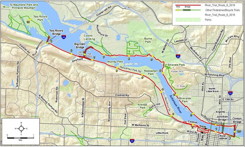
Figure 1. Map of the Arkansas River Trail from arkansasrivertrail.org.
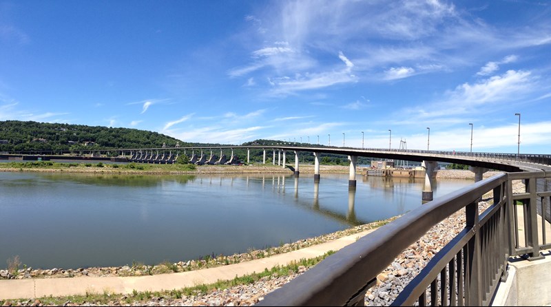
Figure 2. Photo of the Big Dam Bridge from the Foundation's Facebook page.
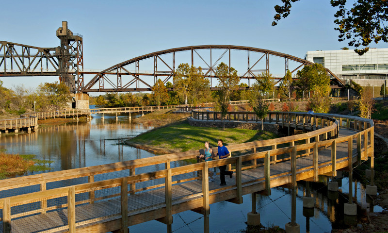
Figure 3. Photo of the Clinton Presidential Bridge from the William E. "Bill" Clark Presidential Park Wetlands from arkansas.com. The Clinton Presidential Library can also be seen to the right.
Arkansas River Trail's Impact
The ART has inspired 17 annual bicycle events within the City, perhaps most notably the Big Dam Bridge 100 and Tour de Rock. It has increased the number of cycling clubs, cyclists within those groups, and organized weekly rides. It has increased the market for local bike shops. The recreational bicycling culture catalyzed by the ART is also increasing bicycle commuting, opening the door to greater health, quality of life, and transportation equity.
Close the Loop
As impactful as the ART Loop has been to a bike-friendly Little Rock, work with the borders of the City of Little Rock remained in 2016 and still remains to make it safe and welcoming for all ages and abilities. Sections of the trail inadequately separated from vehicular traffic decrease use in those sections and limits the trail's use as a loop (Fig. 4). The City has improved several sections of the ART Loop since 2016 but work remains.
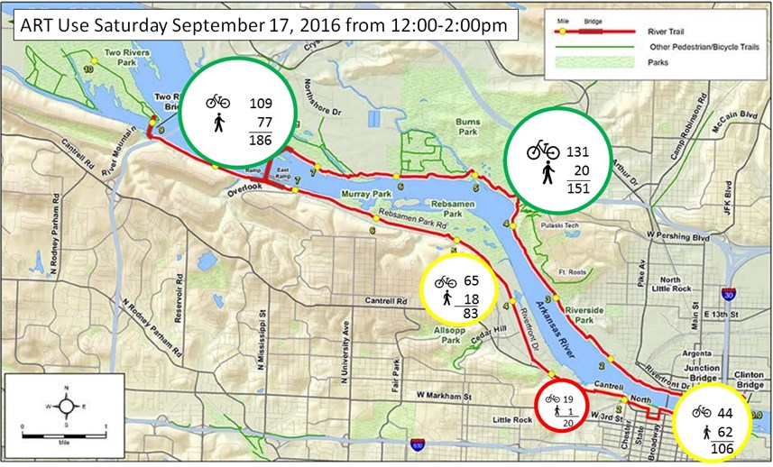 Figure 4. ART usage is greatly affected by levels of traffic stress. This spatial pattern is reinforced by other data indicating fear of motor vehicle conflict suppresses ridership.
Arkansas River Trail Improvements Since 2016
The City of Little Rock has addressed several ART problems since 2016 and the Arkansas DOT has created another river crossing for transportation and recreation at the Broadway Bridge. Among other benefits, the Broadway Bridge connection (with the Clinton Bridge) creates a smaller (2.5 mile) loop within the walkable downtown areas of Little Rock and North Little Rock for less ambitious users.
Increased Accessibility to the Arkansas River Trail Since 2016
The Arkansas River Trail may have been primarily built for recreation, but given the density of origins and destinations along it, with low-stress bicycle connections along it, it can also be used for transportation. These connections can also allow recreational riders to ride to the ART rather than drive to a trailhead to use it. Since 2016, the City has focused on creating these connections.
Upcoming Arkansas River Trail Improvements
Close ART at Medical Mile Ramp: As of February 2020, there is no connection from the western terminus of the Medical Mile to the new UP Bridge, rendering half of the Medical Mile useless. The City has secured $1.6M in Federal Lands Access Program (FLAP) funding to shore up the erosion at this location and build a ramp to create this ART connection.
Allsopp Park Trail: In 2020, the City will construct a trail in Allsopp Park from Hillcrest an existing trail to better connect Hillcrest to the Arkansas River Trail.
Remaining Arkansas River Trail Challenges
While the City has addressed several ART issues since 2016, significant challenges remain.
Close ART at Riverfront Drive: The City improved the section of ART from the Titus Trail to Cedar Hill Dr., but the rest of it must be improved to meet the standards of a separated, shared-use facility appropriate for all ages and abilities.
Close ART at North Cantrell: There is no trail facility from the eastern terminus of the Titus Trail to the West Terminus. The City is working with ArDOT in the context of their replacement of the Cantrell Bridge to create some of this section of ART. The City must improve the ART to meet the separated, shared-use facility appropriate for all ages and abilities.
Close ART at Cantrell/Highway 10: There is no trail facility from the West Terminus to the new bridge. This is arguably most dangerous and broken section of the ART.
Close ART at Rivermarket: While the ART from the Clinton Presidential Bridge to the start of the Medical Mile is mostly separated from vehicular traffic, the trail loses identity and therefore ridership in this section (especially behind Rivermarket). The City must improve the ART to be an easily identified shared-use facility appropriate for all ages and abilities.
