


 Trash & Recycling
 Online Payments
 City Documents
 Parks
Parks
 Traffic Court
 E-NEWS
 EXPLORE
 NEWS
NEWS
Kanis Park Access
Kanis Park is located directly south of I-630, but should primarily serve the neighborhoods within walking distance to it: Briarwood, Brookpark, and Fair Hills (Fig. 1). Of these neighborhoods, Briarwood has the largest number of residents. Best practices suggest that a park should be located within 1/2 a mile from residents (true for these neighborhoods) and the park should be safely accessible by foot or by bike. Accessibility to this park is a challenge currently and may soon become worse.
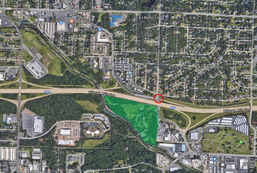
Figure 1. Kanis Park (green area) does not serve the area south of I-630 well due to park proximity (and access by bike or by foot) and does not serve the area north of I-630 because of a lack of access by bike or by foot. Bicycle and pedestrian planning and infrastructure would be necessary at the I-630/Mississippi/Rodney Parham intersection (circled red) to create this accessibility.
I-630/Mississippi/Rodney Parham Intersection
This is a high speed, high volume intersection with complex vehicular movements (Fig. 2). On the right is a two-lane, one-way exit ramp from I-630 with no crosswalk or stopbar. On the top is Mississippi, a four-lane street (the right lane is approximately 26 ft. wide) with a crosswalk that does not match the alignment of the trail on either side. On the left is S. Rodney Parham Rd., a four-lane street with two right-turning lanes and a crosswalk that does not match the trail/sidewalk alignment on either side and no stopbar. On the bottom is a five-lane S. Rodney Parham with two left turn lanes and no crosswalk or stopbar. Especially given the speed that vehicles move through this intersection, the I-630 and the off-ramp embankment limit sight lines to see pedestrians in the intersection. This is not an intersection through which parents of children from the Briarwood neighborhood are comfortable sending their children to play at Kanis Park, but demand for park access is enough to persuade some residents to cross the intersection (Fig. 3).
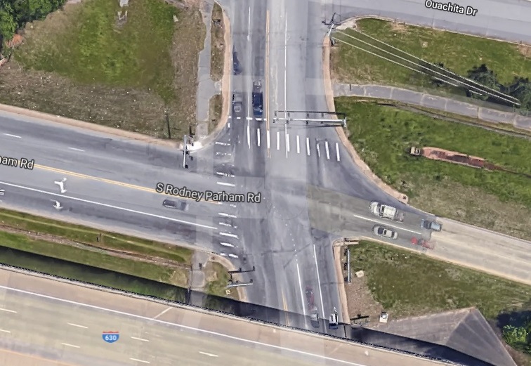
Figure 2. The intersection is poorly designed for pedestrians.
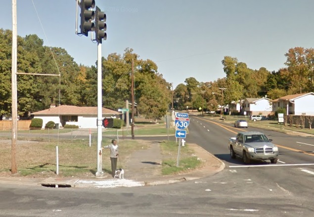
Figure 3. Resident attempts to cross S. Rodney Parham Rd. from the northwest corner of the intersection while walking dog (Google streetview).
The a
rea surrounding the park south of I-630 is mostly commercial and industrial. difficult to access by bike or by foot for .
The Rodney Parham/Mississippi/I-630 intersection is the most significant barrier of access from the north. This is an intersection at which there are many vehicles traveling fast in multiple lanes (Fig. 1). The highway exit and multiple turn lanes further complicate traffic patterns.
ArDOT has plans to expand I-630 in a way that would make this intersection even more challenging for people on bike and on foot. The westbound I-630 exit (Fig. 1, far right) will have a lane exiting onto northbound Mississippi with no stop phase for vehicles (i.e. the traffic light will never stop vehicles exiting I-630 from turning north onto Mississippi). This takes away any opportunity for safe crossing of Mississippi on bike or on foot.
Crossing Mississippi and Rodney Parham at this intersection is critical for the Midline (Fig. 2). The only other
BikePed connectivity is critical at this intersection not only for local park access, but for the proposed regional Midline corridor.
Figure 1. Complex traffic patterns moving a lot of cars at high speeds makes this a dangerous intersection for people on bike or on foot, but connectivity would allow residents north of I-630 to more easily access the park as well as create a critical connection for the Midline. The Midline would require users to cross from the existing BikePed trail on the top right of the picture across Mississippi and then across Rodney Parham to get to Kanis Park at the bottom left of the picture.
The utility of bicycle and pedestrian transportation modes at this intersection requires a greater priority and greater engineering to safely accommodate these modes.
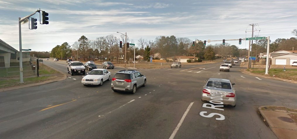
