


 Trash & Recycling
 Online Payments
 City Documents
 Parks
Parks
 Traffic Court
 E-NEWS
 EXPLORE
 NEWS
NEWS
Phase Three Value Added
These are the value-added benefits of Phase 3 assuming the construction of Phases 1&2. This page does not discuss the independent benefits of Phases 1&2, but assumes their completion. For example, discussing a connection between the Phase 2 Focal Area and Kanis Park assumes completion of Phases 1-3 and would fall within this discussion; the Safe Route to School for Meadowbrook Elementary is an independent Phase 1&2 benefit and is outside the scope of this page.
Phase 1 is funded, Phase 2 is under review (2020 ArDOT TAP). If Phase 2 is not funded, some of the benefits discussed below will not materialize. Because Phase 3 constructs the majority of the Tri-Creek Greenway, this discussion may at times echo the Tri-Creek Greenway’s overall benefits.
Regional Connectivity
Phase 3 focuses on regional connectivity. It constructs the bulk of the Tri-Creek Greenway and therefore claims most of its regional connectivity benefits. It creates critical, low-stress crossings of creeks and arterial streets (Fourche Creek, Rock Creek, Colonel Glenn Rd., 36th St., and Kanis Rd.), connecting neighborhoods and creating a low-stress regional corridor that will see high use. As any shared-use path useful for recreation and transportation, it has a high density of street grid connections (Fig. 1).
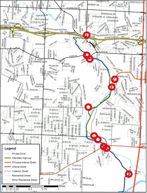
Figure 1. Map of the Tri-Creek Greenway Phase Three with connections to the street grid shown with red circles.
However, the greatest effort to create immediate, regional connectivity in Phase Three was to include an on-street connection (Fig. 2). With this connection, Phase Three immediately connects several existing, piecemeal bicycle facilities to create an interconnected bicycle network (Fig. 3). Phase Three connects the Coleman Creek Trail (UALR), 12th Street bike lanes (ACH), 36th Street bike lanes (Romine Elementary), and the I-630 Trail (District at Midtown) to further expand Phase Three’s immediate reach (Fig. 3). When bicycle accessibility is improved on Jonesboro, a current Pop-Up project, there will be continuous bicycle facilities from the Tri-Creek Greenway to Hillcrest/Heights.

Figure 2. Map of the On-Street component of Tri-Creek Greenway Phase 3.

Figure 3. The Tri-Creek Greenway Phases 1-3 superimposed onto Metroplan's Regional Bike Plan (link's Fig. 5-10) to illustrate immediate and future connectivity at local and regional scales.
Local Connectivity
Phase Three takes a literal approach to Mayor Scott's goal to #UniteLR by better connecting the pockets within the Phase Three Focal Area and connecting the Phases 1&2 and Phase Three Focal Areas. This connects almost 20,000 Little Rock residents to one another and to job and recreation opportunities (Fig. 4).

Figure 4. Map of the Phase Three five pockets with numbers of residences and households in each. See Table 2 below for explanation about P3 - Black and P3 - Green.
Safe Route to Parks
Phases 1-3 will connect six City parks. Phase 3 will connect over 7,400 residents in the Phase 2 Focal Area to Boyle and Kanis Parks. Kanis Park features a skate park and Boyle Park features an emerging network of mountain bike trails; these amenities are not found in any Phase Two focal area park. Phase 3 will also connect over 10,000 residents in the Phase 3 Focal Area to First Tee, Western Hills, Hindman, and Brodie Parks in the Phase Two Focal Area. Unique Phase 2 Focal Area park amenities include a new, premier disk golf course and a traditional golf course.
Transportation Equity (Income)
The entire Tri-Creek Greenway alignment is in an underserved area of Little Rock; Phase 3 is no exception. Of the 10 Census Block Groups that fall entirely or partially in the Phase 3 Focal Area, all have median household incomes and median home values lower than the Little Rock average (link’s Table 1). Phase 3 Focal Area includes some of the highest poverty areas and zero car household areas in Little Rock (link's Figs. 2-4). Phase 3 can provide a primary or auxiliary route to access school, jobs, and other needs, decreasing truancy and increasing job retention, transportation equity, and household resiliency. Phase 3 will also provide access to Rock Region Metro Routes:
- Route 14: Phase Three New Main and New Connection (Colonel Glenn)
- Route 3: Phase Three New Main and Connection (Kanis)
- Route 3: Phase Three New On-Street (12th)
- Route 17: Phase Three New On-Street (University Ave.)
- Route 22: Phase Three New On-Street (University Ave.)
- Route 16: Phase Three New On-Street and Coleman Creek Trail (UALR)
Increase BikePed Safety
Biking and walking are particularly risky ways to move in Little Rock. This danger can discourage active transportation (and thereby decrease physical activity) for residents who have transportation options, but can simply increase the danger of living in Little Rock for residents without those options. The third most likely place to get struck by a car while walking or biking is in the Phase Three Focal Area, along Colonel Glenn between University and 36th (Fig. 5). Phase Three creates a safe BikePed crossing under Colonel Glenn.

Figure 5. Phase 3 would create a safe crossing at the third most dangerous corridor in Central Arkansas (Colonel Glenn between University and W. 36th). Metroplan 2015 Crash Analysis, Link's Figure 5 and Table 2.
Safe Routes to Schools
Coupled with low-stress residential streets, Phase 3 provides Safe Routes to Schools for Bale and Romine Elementary School, Henderson Middle School, and Parkview Arts and Science Magnet High School.
Risk Equity (Race)
As discussed on the main page, the risk of being struck by a car while walking and biking is much higher for black residents than white residents. The Tri-Creek Greenway runs through disproportionately Black census blocks; Phase 3 is no exception. Of the 10 Census Block Groups that fall entirely or partially in the Phase 3 Focal Area, eight have a higher than average Black population (link’s Table 1). Phase 3 will increase bicycle and pedestrian safety for all users, but because of where we are building it, it will disproportionately increase the safety of Black residents and decrease transportation safety inequalities.

Figure 6. Map of the five pockets united by Phase Three and the percent of residents within each who are black.
Quality of Life and Health Equality
Race and income affect health outcomes in part through differences in opportunities for active recreation and transportation. As discussed, Phase 3 runs through predominately Black and low-income neighborhoods. It will facilitate active recreation and transportation as well as better access to City parks for additional recreational opportunities.
