


 Trash & Recycling
 Online Payments
 City Documents
 Parks
Parks
 Traffic Court
 E-NEWS
 EXPLORE
 NEWS
NEWS
Resources
The following resources are relevant to making Little Rock more bicycle- and pedestrian-friendly. Itemized references are specific to Little Rock and Arkansas and the buttons on the bottom contain non-regionally specific references. Please let BikePed Little Rock know how you are using these resources and if you have any other resources to share.
By Subject
By Location - City of Little Rock Documents
Vision Zero Resolution 2024
The City of Little Rock has committed to decreasing traffic fatalities and serious injuries by 40% by the year 2040.
Bike Friendly Community Committee Goals 2019
The Bike Friendly Community Committee adopted the following goals to promote bicycling and transportation choice in Little Rock.
Mayor Scott's Mobility Agenda 2018
Mayor Scott has highlighted Complete Streets and bicycle and pedestrian mobility in his vision for the future of our transportation network. Read more here.
Complete Streets Resolution 2013
The Complete Streets Resolution asked City staff to draft a Complete Streets Policy (which became part of the Complete Streets Ordinance) and revise the Master Street Plan to reflect Complete Streets principles.
Complete Streets Ordinance 2015
The Complete Streets Ordinance, nationally recognized as one of the best new complete streets ordinances in 2015, states Little Rock's intention of creating a transportation network friendly to all modes of traffic, including bicycles, pedestrians, automobiles, freight haulers, and the disabled community.
Master Street Plan (including Master Bike Plan) 2018
The Master Street Plan illustrates how the City of Little Rock intends to alter and expand our transportation network in the near future. As an important transportation mode, the Master Street Plan includes the Master Bike Plan to illustrate our intended bicycle transportation network (Sections 4 and 5, pages 32-43). The Master Street Plan also includes Design Standards and Design Options for bicycle and pedestrian facilities that inform how our streets will look in the future (pgs. 10-24), (2015).
Master Trail Plan 2016
This is a compilation of ideas for an off-street BikePed trail network throughout Little Rock. The proposed trails are not upcoming projects, but an attempt to conceptualize how an off-road trail network could be created in our highly developed urban landscape. Please look it over and contact BikePed Little Rock with your comments, suggestions, and additions.
LR Bike Ways Interactive Map
At first glance, this interactive map may seem redundant with the Master Bike Plan interactive map below, but they contain slightly different information presented differently to serve two different purposes. LR Bike Ways was developed for the bike commuter attempting to chart a route from an origin to a destination. It has all bicycle infrastructure and fog lanes (which some bicycle commuters will choose to use) and it doesn't have planned routes.
Master Bike Plan and Master Trail Plan Interactive Maps
The Master Bike Plan has the bicycle infrastructure proposed and infrastructure installed on the adopted Master Bike Plan. It does not contain existing bicycle infrastructure not on the Master Bike Plan, such as the Van Buren bike lanes. The Master Bike Plan Interactive map is superior for tracking our progress in implementing the Master Bike Plan; LR Bike Ways is superior as a tool to help a bike commuter get from here to there. To access these interactive maps, click on "Layer List" (bottom row of buttons, third from the left). Uncheck "Master_Street_Plan" and check "Master_Bike_Plan" and/or "Master Trail Plan". Use "+" and "-" buttons in the top left corner to zoom in and out.
Central High Corridor Report 2017
This report considers the Southwest Trail route proposed in ALTA Planning's corridor study in greater detail between the Arkansas River (where it will link to the Arkansas River Trail) and Central High. More information about the Southwest Trail can be found here.
By Location - Local (but not City of Little Rock documents)
Central Arkansas Safety Action Plan 2024
Little Rock Transportation Report 2024
Little Rock's Pedestrian Equity 2024
Clinton School of Public Service's Solomon Quarm considered pedestrian equity in Little Rock.
Vulnerable Road User Assessment 2023
Cambridge Systematics conducted a statewide analysis of the corridors with the most serious injuries and fatalities to people walking and biking. Several Little Rock corridors were identified.
Parking Reform in Downtown Little Rock 2023
Clinton School of Public Service's Gillian Gullett conducted an eye-opening assessment of the glut of surface parking in downtown Little Rock, the harmful effects this has on our downtown, and ways we can address this challenge.
Highway 70 (Broadway) Study
ARDOT completed an assessment of Broadway and determined a road diet is feasible from Roosevelt to 17th Streets.
Active Transportation in Little Rock 2021
In a follow up to On the Right Track (2014), Clinton School of Public Service's Leslie Parker considered how Little Rock now compares to peer cities and made specific recommendations to improve walking and biking in Little Rock.
Cantrell Road @N Bryant St. Pedestrian Audit
The City of Little Rock and Garver Engineering performed a pedestrian audit of Cantrell at N. Bryant to determine the need for a pedestrian crossing of Cantrell at this location.
On the Right Track 2014
This report considers the state of active transportation in Little Rock and is informed by the experience of similar cities to improve our opportunities for active transportation.
Pedestrian/Bicyclist Crash Analysis 2015
This Metroplan report summarizes the pedestrian and bicycle crashes over the last 10 years, indicating where crashes are most frequent, demographics, and injury severity.
Southwest Trail Corridor Study 2015
The Southwest Trail is a proposed 63-mile BikePed trail connecting Little Rock to Hot Springs. This is ALTA Planning's Southwest Trail Corridor & Economic Impact Study considering the route for the trail and its impacts on the communities it links.
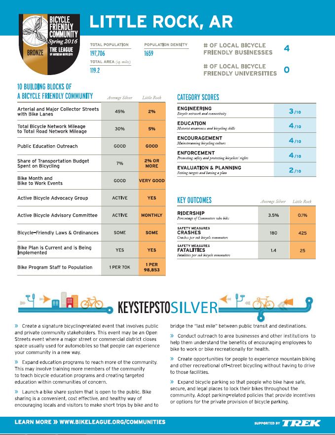
LAB Report Card 2016
Little Rock is a Bike Friendly Community at the Bronze (entry) level. This is the accompanying feedback from the League of American Bicyclists (LAB) to increase our bike-friendliness. Click here to learn how we propose to address LAB's feedback.
LAB Report Card 2013
Before earning Bike-Friendly (Bronze) status in 2016, Little Rock earned Honorable Mention status in 2013. While the 2016 feedback (above) is more current, the "long-form" nature of the 2013 report still offers valuable insights.
Central Arkansas 2050 (2018)
This revision to Imagine Central Arkansas, our community's Long-Range Metropolian Transportation Plan, considers policy with a 20-year transportation and land use plan projection window for Central Arkansas, including BikePed-friendliness.
Central Arkansas 2050 Public Outreach Summary
This document records public outreach efforts for Central Arkansas 2050, primarily from the Imagine Central Arkansas iteration.
MOVE Central Arkansas
A strong transit system is important part of being able to effectively move in Little Rock on foot and by bike. Transit can be a long-distance mobility solution and the "last mile" to and from transit can be completed on foot or by bike. Mayor Scott's Mobility Agenda highlights the importance of transit to Little Rock mobility. Check out Rock Region Metro's plans for the future!
Central Arkansas Livability Index 2014
This Metroplan document considers different measures of livability including walking (pg. 5) and biking (pg. 6).
Highway 10 Improvement Summary Executive Summary 2013
This ArDOT document summarizes the Cantrell (Highway 10) widening project.
Broadway Street Pedestrian/Bicycle Crash Analysis 2012
Broadway, between the Arkansas River and I-630, is by far the most dangerous pedestrian corridor in all of Central Arkansas (Table 2), including three of the four most dangerous intersections for pedestrians in Central Arkansas (Table 1). This Metroplan document considers the circumstances of pedestrian crashes which will help prioritize interventions to increase the safety of the corridor.
Central Little Rock Route 2011
Arkansas Transportation Planning Conference 2009
By Location - Arkansas
Arkansas Vulnerable Road User Safety Assessment 2023
Arkansas Strategic Highway Safety Plan 2022
Bike Arkansas Magazine
Check out Bike Arkansas Magazine for informative articles on all types of biking (road, mountain, commuter) in Arkansas!
Arkansas Bicycle and Pedestrian Laws
These are the laws, compiled by Bicycle Advocacy of Central Arkansas (BACA), that relate to the rights and responsibilities of bicyclists and pedestrians on the roadway.
Arkansas Strategic Highway Safety Plan 2017
The SHSP identifies Vulnerable Road User safety (including bicyclists and pedestrians) as a Critical Emphasis Area (pg. 34). Note that while overall traffic fatalities are increasing over time, bicycle and pedestrian fatalities are increasing (pg. 35). This is consistent with national trends.
ArDOT Action Plan for Implementing Pedestrian Crossing Countermeasures at Uncontrolled Locations 2018
ArDOT is working to improve pedestrian crossings at places where there are no traffic lights to stop vehicles.
Summary of State Speed Laws 2013
Automated red light and speed enforcement cameras have been shown to increase safety for people walking and on bike, but are effectively illegal in Arkansas (only legal within school zones or railroad crossings, with an officer must be present and issuing the citation immediately following the violation) (pg. 17). Arkansas is currently reviewing this policy.
Arkansas Bicycle and Pedestrian Transportation Plan 2017
This is ArDOT's Master BikePed Plan. Here is an article highlighting some of its findings.
LAB Report Card - Arkansas 2017
In October 2017, the League of American Bicyclists ranked Arkansas the 35th most bike-friendly state in the country (a slight improvement from 2015's 36th place). This was the feedback Arkansas (ArDOT) received to improve our ranking.
ArDOT Bicycle and Pedestrian Design Standards 2005
This memorandum outlines ArDOT design standards for bicycle and pedestrian facilities, under what circumstances ArDOT would install these facilities, and who is responsible for their cost.
ArDOT Bike Suitability Map front and back 2016
AHTD created a resource to help plan a bicycle tour of Arkansas. It has a map of Arkansas state highways and their daily traffic counts, bike trail locations, and other helpful resources.
Arkansas Statewide Comprehensive Outdoor Recreation Plan (SCORP) 2013
Arkansas Department of Parks and Tourism's SCORP surveys demand for different types of outdoor recreation and the opportunities and facilities currently available.
ArDOT's Average Daily Traffic Counts (1986-present)
This interactive map of average daily traffic (ADT) counts can be a useful tool to consider street designs to accommodate people walking or biking on a street in the context of vehicular traffic. Clicking on each dot provides an ADT history at that location.
By Location - Referencing Little Rock
The Best Complete Streets Policies of 2015
This is the document in which Smart Growth America recognized Little Rock as having one of the best new Complete Streets policies in 2015. See also
Dangerous by Design 2019
Smart Growth America ranked Little Rock/Central Arkansas the 19th most dangerous metropolitan areas to walk out of the 104 largest metropoltan areas in the country, an improvement over the 14th most dangerous ranking in 2016, but still concerning.
